


As a public historian and National Geographic Explorer, I’m constantly on the trail of interesting stories that connect a series of events dating back several centuries but continue to resonate into modern times. On a recent road trip through the American South, my partner, National Geographic photographer Kris Graves, and I drove through Tuskegee, Alabama, where we found a connection to a time long before human beings walked the Earth.
It’s a story of how the geology of the Cretaceous Period, between 70 and 100 Million years ago, emphatically changed the course of American history.
Where the South as we know it began
About 80 miles from Tuskegee, along highway 431, we approached Horseshoe Bend National Military Park. Not to be confused the “Horseshoe Bend” segment of the Colorado River in Arizona, this site, established in 1959, is the site of the Battle of Horseshoe Bend. My first assumption was that this was a battlefield from the Civil War. But as it turns out, I was off by more than 50 years.

A map that shows fortifications and troop positions during war with Native Americans in 1814.
Map via Library of Congress, Geography and Map Division
It was here in 1814, during the War of 1812, that General Andrew Jackson came to national prominence by defeating the Muscogee Indians. The Native People who had settled on the land surrounding the Tallapoosa River watershed, offered the last resistance against the expansion of the newly founded United States of America into this southeastern corner of the continent.
(These national park trails were created by America’s first Black soldiers)
After the Battle of Horseshoe Bend, the Treaty of Fort Jackson ceded more than 23 million acres of Native land to the U.S. Government and opened the Mississippi Territory for pioneer settlement. This area ultimately created the states we now call Alabama and Georgia. It has been suggested by historians that this is where the South as we know it today begins.

A TASTE OF CATALONIA
This was a geographic flash point of American history. After the Battle of Horseshoe Bend, the Muscogee Indians were summarily displaced and sent to reservations in Oklahoma and other points on the map west of the Mississippi River. From 1816 to 1840 native people were forced to travel west along a path known commonly as the Trail of Tears.
Once removed, Native People were replaced with white settlers who quickly discovered the rich soil in this location was perfect for the cultivation of cash crops such as indigo, corn, rice and cotton. In letters to his wife, Rachel, Andrew Jackson writes about the soil of Alabama: “The lands through which we passed are some of the richest this country can boast—well watered and abundantly fertile, they will no doubt soon be settled by a happy and prosperous people.”

A vintage, open-cockpit biplane called the PT-13D Stearman Kaydet was used to train the first generation of Black American combat pilots at the Tuskegee Institute.
Photograph By Kris Graves.

Tuskegee airmen training in 1942.
Photograph By Library of Congress, Prints & Photographs Division, Farm Security Administration/Office of War Information Black-and-White Negatives
Ancient organism laid the foundation for the South’s fertile land
There’s a deep reason for the richness of the soil they remarked on there.
Over 70 million years ago, during the late Cretaceous period, the southeastern U.S. was a warm, subtropical region covered by a vast shallow sea known as the Western Interior Seaway. Much of the area was a coastal plain with swamps, rivers, and dense vegetation. Dinosaurs like hadrosaurs, tyrannosaurs, and ceratopsians roamed the land, while giant marine reptiles such as mosasaurs and plesiosaurs dominated the waters. The climate was humid, and the region was rich in diverse plant and animal life, resembling modern coastal wetlands and estuaries.
Over millions of years, marine organisms like plankton and shellfish accumulated on the seafloor, forming thick deposits of calcium-rich limestone. When the sea receded, these limestone deposits weathered into fertile, alkaline soils that became ideal for agriculture. This rich, dark soil gave the Black Belt—an area that stretches from east-central Mississippi through central Alabama and into western Georgia–its name and later made the region a prime area for cotton farming in the 19th century.
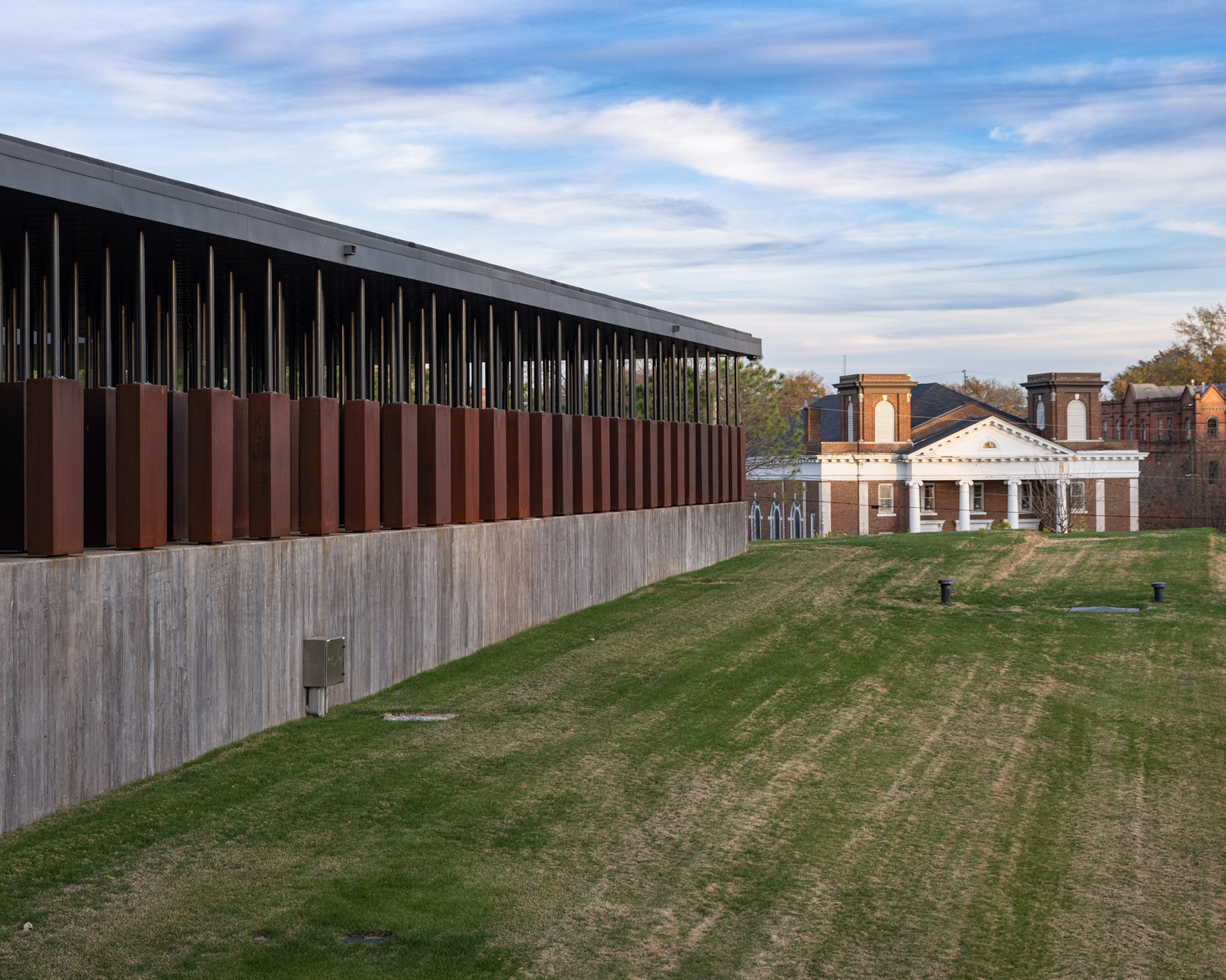
The National Memorial For Peace and Justice in Montgomery Alabama is dedicated to Black Americans who were terrorized by lynching throughout the late 19th and 20th Centuries. A series of pillars hang in the display to represent the many counties across the U.S. where incidents of public execution were perpetrated. The name of each victim is inscribed on the pillar of the county in which they were killed.
Photograph By Kris Graves
The ancient history still leaves an imprint on the present
The geological landscape of the Black Belt created the physical environment where Black Americans would be subjected to the cruel exploitation of their labor. First through chattel slavery, then by a system of inequitable sharecropping and convict leasing programs, people of African descent would be made to work the soil of this region so rich in fossil decay.
You May Also Like
But labor-intensive commodities like cotton require a great many hands to reap their benefits. The necessity for a dedicated workforce provided the economic incentive to expand and intensify the institution of slavery. In this place, at this time, through the Civil War, we see an ever-increasing concentration of enslaved Black Americans. And, their descendants still live there today.
In the 21st Century, the descendants of the formerly enslaved make up large segments of the population in these areas. The Black Belt’s geological, historical and demographic legacy, combined with ongoing advocacy efforts, has made it a critical region for Black voter registration and political empowerment throughout the United States.
(I took a leap of faith—and it led me in search of history’s lost slave ships)

Coretta Scott King, John Lewis and a crowd of 5,000, march across the Edmund Pettus Bridge from Selma, Alabama Saturday, March 8, 1975. The historic march takes place on land that was made fertile by a ancient sea.
Photograph By Associated Press
The geographic footprint of the Black Belt directly overlays the route of the U.S. Civil Rights Trail. Defined by a series of historic parks and monuments managed by the National Park Service, this path traces a timeline through critical moments in Black American history. From the murder of Emmitt Till near Greenwood, Mississippi, to where Rosa Parks refused to give up her seat on a bus in Montgomery, to the site of the 16th Street Baptist Church Bombing in Birmingham, to where John Lewis led the march for voting rights in Selma across the Edmund Pettus Bridge, to the training base of the Tuskegee Airmen, each of these locations and corresponding events can be traced back in history to the formation of soil made fertile almost 100 million years ago.
Despite the passage of time, even ions of geological transformation, history never gets old. There is always something new to learn from the past.
James Edward Mills is a freelance journalist and National Geographic Explorer who specializes in stories about the history our National Parks and environmental conservation on public land.
The nonprofit National Geographic Society, committed to illuminating and protecting the wonder of our world, funded Explorer James Edward Mills’s work. Learn more about the Society’s support of Explorers.


